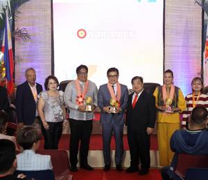


Photo 1: Mr Luke Goh Chief Executive, National Environment Agency (NEA) (second from left) and Mr Colin Low, Chief Executive of Singapore Land Authority (SLA) (second from right) signed the Memorandum of Understanding to share Global Navigation Satellite System (GNSS)-derived moisture data for weather monitoring application at the World Cities Summit 2022. The signing was witnessed by Ms Koh Li-Na, Assistant Chief Executive, NEA (first from left) and Mr Bryan Chew, Assistant Chief Executive, SLA (first from right). Photo credit: Singapore Land Authority
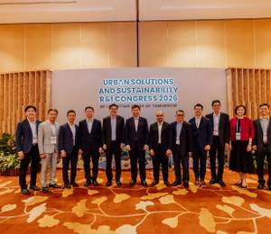
Photo 2: The GNSS reference station at Upper Air Observatory. Photo credit: Singapore Land Authority
Singapore – The National Environment Agency (NEA) and the Singapore Land Authority (SLA) have signed a Memorandum of Understanding (MOU) to develop the use of Global Navigation Satellite System (GNSS) data obtained from SLA’s Singapore Satellite Reference Network (SiReNT) to enable NEA to better monitor island-wide atmospheric moisture. The five-year collaboration is aimed at benefitting Singapore with additional data for weather monitoring, as well as facilitating exploratory studies for weather forecasting.
Under the MOU, Meteorological Service Singapore’s (MSS) GNSS station will be integrated into SiReNT, and enable MSS to obtain islandwide, continuous and near real-time atmospheric moisture readings. This non-conventional moisture data will augment MSS’s existing observation network data, providing higher resolution and more frequent observation data, which allows for investigative studies into potential applications for weather forecasting.
The collaboration will also expand SLA’s SiReNT station network, which currently comprises nine reference stations spread across Singapore. With the addition of NEA’s GNSS base receiver station at Upper Air Observatory (UAO) that will be incorporated into SiReNT, together with two upcoming additional coastal SiReNT reference stations, network will be expanded to 12 stations with additional receivable data. The SiReNT system can correct positional errors in GNSS signals and produce precise positioning data of up to 3 cm in accuracy. The SiReNT technology supports innovation in diverse industries such as autonomous vehicles, construction automation and logistics, and monitoring of land height and sea-level changes in Singapore. The expansion of stations by the end of 2022 will further improve stability to services and applications in various key industries currently supported by SiReNT. It can also be further leveraged for novel uses in climate-related scientific studies.
Mr Luke Goh, CEO of NEA, said, “The collaboration between NEA and SLA highlights our commitment to achieve synergies and tap on enablers across the public sector. This partnership provides a platform for NEA to utilise SLA’s expertise in GNSS data collection and processing, enabling NEA to explore non-traditional methods to enhance our weather monitoring and forecasting capabilities.”
Mr Colin Low, CEO of SLA said, “This collaboration with NEA is part of SLA’s continuous effort to work with parties from both private and public sector to unlock diverse uses for SiReNT and SLA’s many geospatial products. We believe that by pooling expertise from various parties we can spark more innovation and uncover practicable solutions that can benefit Singapore and our industries. We are excited to work with NEA to study the novel use of SiReNT data for enhanced weather monitoring and investigative studies in weather forecasting and climate change. The many experiences shared and gained from this collaboration will be a building block for future innovations in this field.”